Travel Itinerary
*Sichuan Scenic Spots (Beautiful) — 5 Days | Xinjiang (Even More Beautiful) — 10 Days
Silk Road Xinjiang: 10-Day Grand Tour
Experience the Beauty of North & South Xinjiang · Pamir Plateau · Ancient Silk Road · Mountain Mysteries
10 Days of Essence | 15+ Core Attractions | 9 Nights in 4-5 Star Hotels | 2000+ km Epic Journey
Complete 10-Day Itinerary Overview
Depart from Kashgar, China's westernmost city, traverse the majestic Pamir Plateau, follow the ancient Silk Road eastward, and arrive in Urumqi at the foot of the Tianshan Mountains. This comprehensive journey covers all the essential highlights of North and South Xinjiang, spanning over 2000 kilometers through diverse landscapes and rich cultural heritage.
Day 1: Arrival in Kashgar · First Impressions of the Western Regions
24-hour airport/station pickup and transfer to hotel. Spend the day acclimatizing to the local climate and time zone. Optional self-guided exploration of Kashgar's vibrant city streets to experience the exotic atmosphere of South Xinjiang.
Accommodation: Kashgar Ancient City Kunlun Taye Fei Resort (4-star)
Day 2: China-Pakistan Highway · Twin Lakes of the High Plateau (approx. 300 km)
Early departure from Kashgar on the legendary China-Pakistan Friendship Highway. Visit White Sand Lake (approximately 1.5 hours), then continue to Karakul Lake (approximately 1.5 hours), arriving in Tashkurgan County in the evening. Total distance: approximately 300 km, driving time: approximately 6 hours.
Accommodation: Dongxun Cultural Hotel (4-star)
Day 3: Panlong Ancient Road · Pamir Plateau Mysteries (approx. 200 km)
Explore the spectacular Panlong Ancient Road (approximately 1.5-2 hours), visit Bandier Blue Lake (approximately 0.5-1 hour), experience authentic Tajik family hospitality (approximately 30 minutes), and tour the Pamir Tourism Area including Golden Grassland and Stone City (approximately 1.5 hours). Total distance: approximately 200 km, driving time: approximately 5 hours.
Accommodation: Dongxun Cultural Hotel (4-star)
Day 4: Father of Glaciers · Return to Kashgar (approx. 360 km)
Stop at Tahaman Wetland for photos, then visit Muztagh Ata Glacier Park (approximately 3 hours). Return to Kashgar in the evening. Total distance: approximately 360 km, driving time: approximately 6 hours.
Accommodation: Kashgar Ancient City Kunlun Taye Fei Resort (4-star)
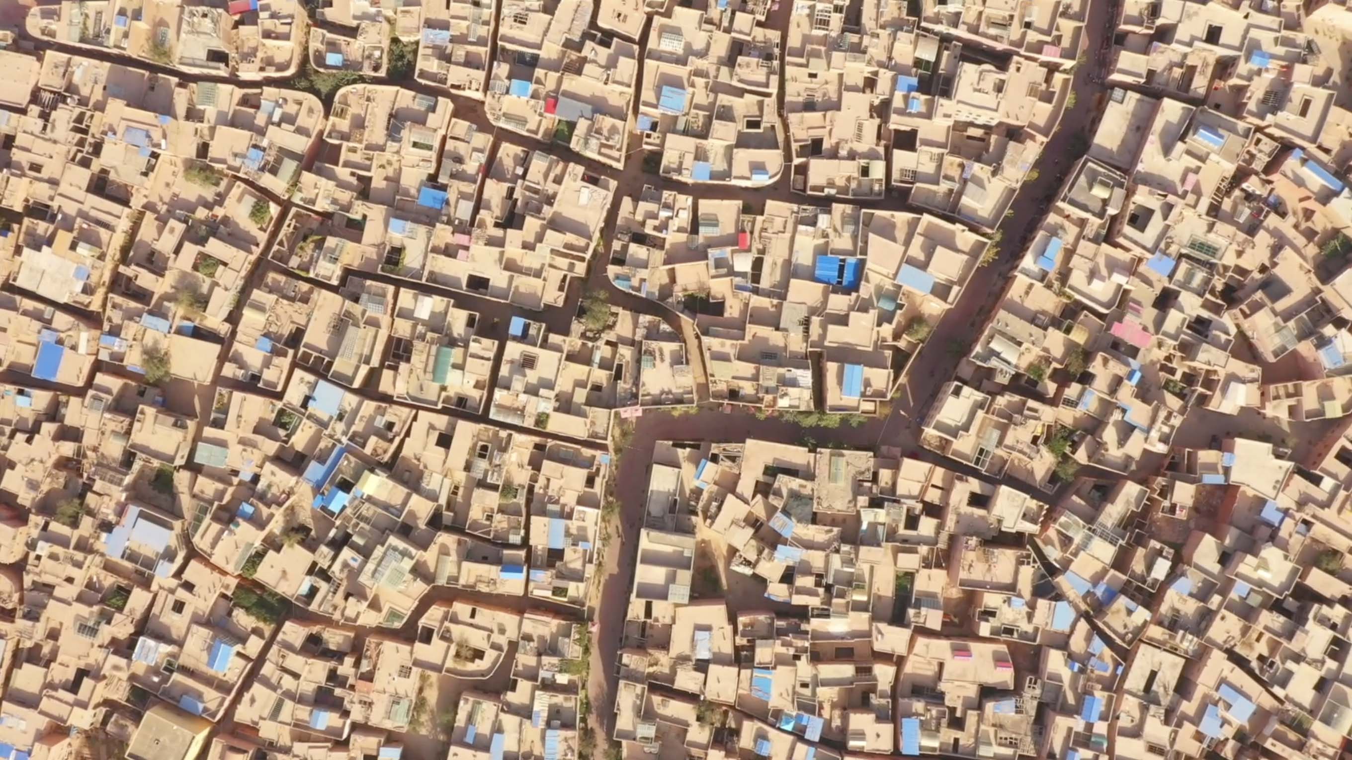
South Xinjiang · Kashgar Ancient City
China's westernmost city and the most brilliant jewel on the Silk Road, a living thousand-year-old ancient city where history breathes through every corner.
🏛️ Kashgar Ancient City
Rating: 5A Scenic Area | UNESCO World Cultural Heritage Candidate | Recommended Duration: Approximately 2 hours
Kashgar Ancient City, known in Uyghur as "Kashgar," meaning "place where jade is gathered," is one of the world's largest and best-preserved rammed earth building complexes, earning the title of "Living Thousand-Year Western Region Ancient City." With over 2,000 years of history, it stands as the most important commercial center and cultural crossroads on the ancient Silk Road.
Historical Significance: Located at the eastern foot of the Pamir Plateau, Kashgar has been the junction of the northern and southern routes of the Silk Road since the Han Dynasty. Zhang Qian passed through here during his diplomatic mission to the Western Regions, and the Tang Dynasty monk Xuanzang also stayed here during his journey to India. The ancient city's labyrinthine streets and layered earth-colored buildings house traditional residences, bazaars, handicraft workshops, and authentic cuisine, all permeated with rich Uyghur culture. The city served as a filming location for "The Kite Runner," showcasing its exotic charm to the world.
Travel Tips: Visit early morning or at sunset for the best lighting. Wearing brightly colored clothing provides excellent photo opportunities.
🕌 Id Kah Mosque
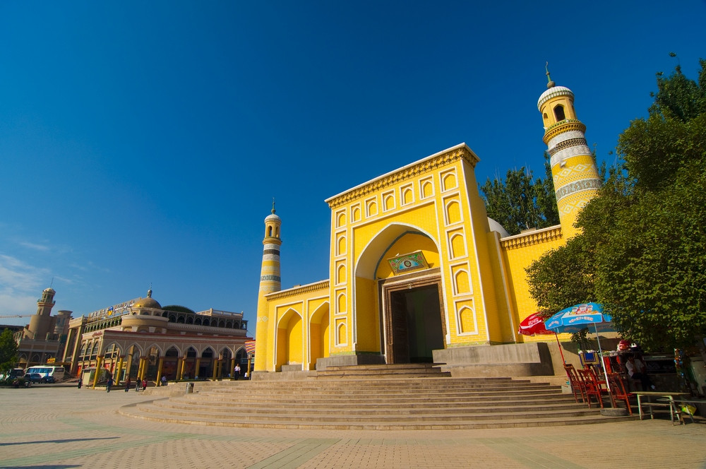
Rating: Xinjiang's Largest Mosque | National Key Cultural Relic | Recommended Duration: Approximately 1 hour
Built in 1442, the Id Kah Mosque is Xinjiang's largest and most representative Islamic mosque, as well as one of Central Asia's most famous religious sites. The mosque complex covers approximately 16,800 square meters and can accommodate over 10,000 worshippers at once.
Architectural Artistry: The mosque's architecture blends Central Asian, Western Asian, and Chinese styles, featuring a striking yellow exterior with towering minarets and graceful domes. The ornate arched entrance displays intricate Islamic geometric patterns. During Islamic festivals, tens of thousands of Muslims gather here for grand celebrations. "Id Kah" in Uyghur means "Festival Prayer Ground," and the mosque serves as the spiritual landmark of Kashgar Ancient City.
Travel Tips: Please respect religious customs when visiting. Women should wear long skirts and head coverings. Avoid visiting during prayer times.
🏘️ Gaotai Residential Area
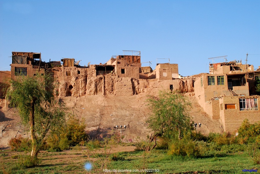
Significance: Living Museum of Uyghur Folk Culture | Intangible Cultural Heritage | Recommended Duration: Approximately 1 hour
Located at the northeastern corner of Kashgar's old city, perched on a 30-meter-high yellow earth cliff, the Gaotai Residential Area represents a typical example of Kashgar's thousand-year-old Uyghur residential complex. Houses built into the cliff form a maze-like labyrinth, with the highest point offering panoramic views of the entire old city.
Cultural Heritage: With approximately 2,000 years of history, the Gaotai area preserves traditional crafts including pottery, embroidery, copperwork, and musical instrument making. Residents continue their ancestral ways of life, maintaining traditional customs. The pottery-making techniques here are recognized as national-level intangible cultural heritage, allowing visitors to witness artisans' hand-throwing techniques firsthand. Every carved wooden door and painted wall testifies to Kashgar's millennia-old Silk Road civilization.
Travel Tips: The terrain is steep; wear non-slip shoes. Handmade pottery souvenirs are available for purchase.
Pamir Plateau · Roof of the World
Atop the world's roof, snow-capped peaks, ancient glaciers, and pristine alpine lakes create nature's most spectacular masterpieces.
"The Pamir Plateau, known in antiquity as the 'Onion Mountains,' rises above 4,000 meters average elevation, making it one of Central Asia's highest plateaus. As a crucial waypoint on the ancient Silk Road and a crossroads of Eastern and Western civilizations, the Tajik people have guarded this pristine highland realm for generations."
🏖️ White Sand Lake
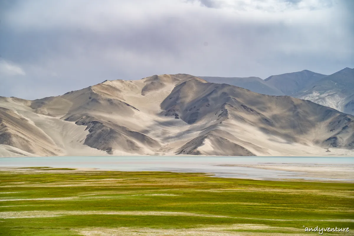
Characteristics: Iconic Pamir Plateau Landscape | Elevation: Approximately 3,400 meters | Recommended Duration: Approximately 1.5 hours
Situated on the Pamir Plateau, White Sand Lake is recognized globally as a premier high-altitude photography destination. The lake waters display rich layers of blue-green hues, while surrounding white sand dunes create a striking visual contrast. Under varying light conditions, the landscape transforms into a dreamlike panorama.
Geological Formation: The white sand dunes result from wind-transported quartz sand accumulation, creating a rare phenomenon of desert and alpine lake coexistence found nowhere else on Earth. Often called "the Maldives of the plateau," the lake is frequently visited by grazing yaks, creating a natural high-altitude pastoral scene.
Travel Tips: High-altitude UV radiation is intense; comprehensive sun protection is essential. The high elevation may cause mild discomfort; avoid strenuous activity and inform your guide if you experience any symptoms.
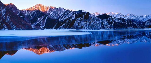
🏔️ Karakul Lake
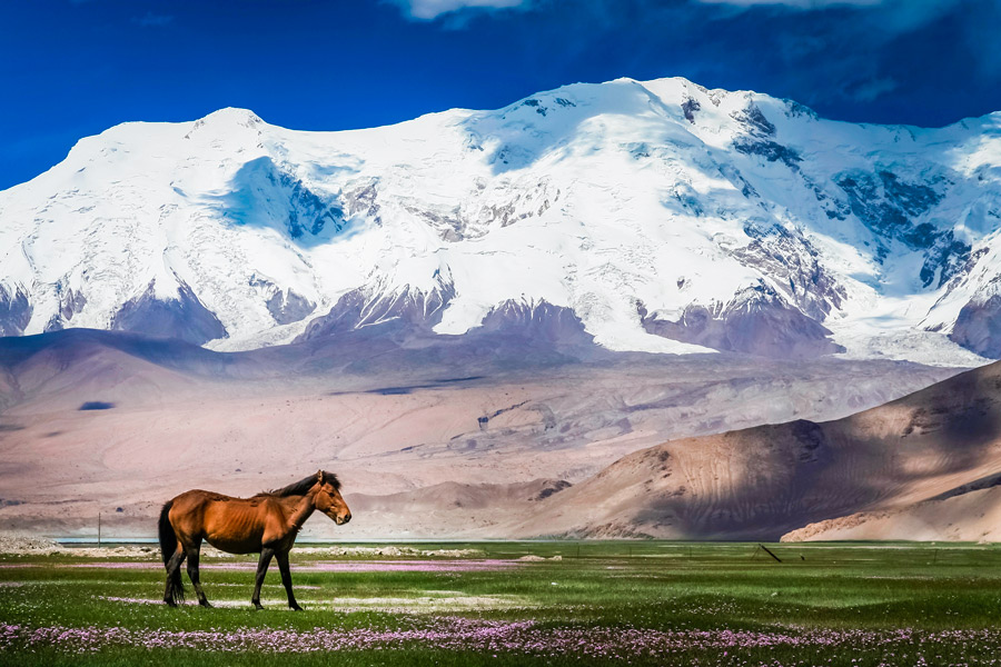
Characteristics: Sacred Lake at the Foot of the Father of Glaciers | Elevation: 3,600 meters | Recommended Duration: Approximately 1.5 hours
Nestled at the foot of Muztagh Ata Peak, the "Father of Glaciers," Karakul Lake (meaning "black lake" in Uyghur) sits at 3,600 meters elevation and offers the best vantage point for viewing Muztagh Ata. The pristine waters eternally mirror the snow-capped peaks and glaciers, creating a breathtaking panorama when weather permits.
Natural Wonder: This high-altitude tectonic lake formed approximately 10,000 years ago during the last ice age. Covering about 27 square kilometers with depths reaching 30 meters, the lake serves as traditional pastureland for Kyrgyz and Tajik herders. Each summer, these nomadic peoples graze yaks and camels here, maintaining unique high-altitude pastoral traditions. The lake's reflection of Muztagh Ata Peak is considered "one of the world's most beautiful mountain reflections."
Travel Tips: Strong winds are common; bring windproof outerwear. Early morning offers the clearest mountain reflections; early rising is recommended for photography.
🛣️ Panlong Ancient Road
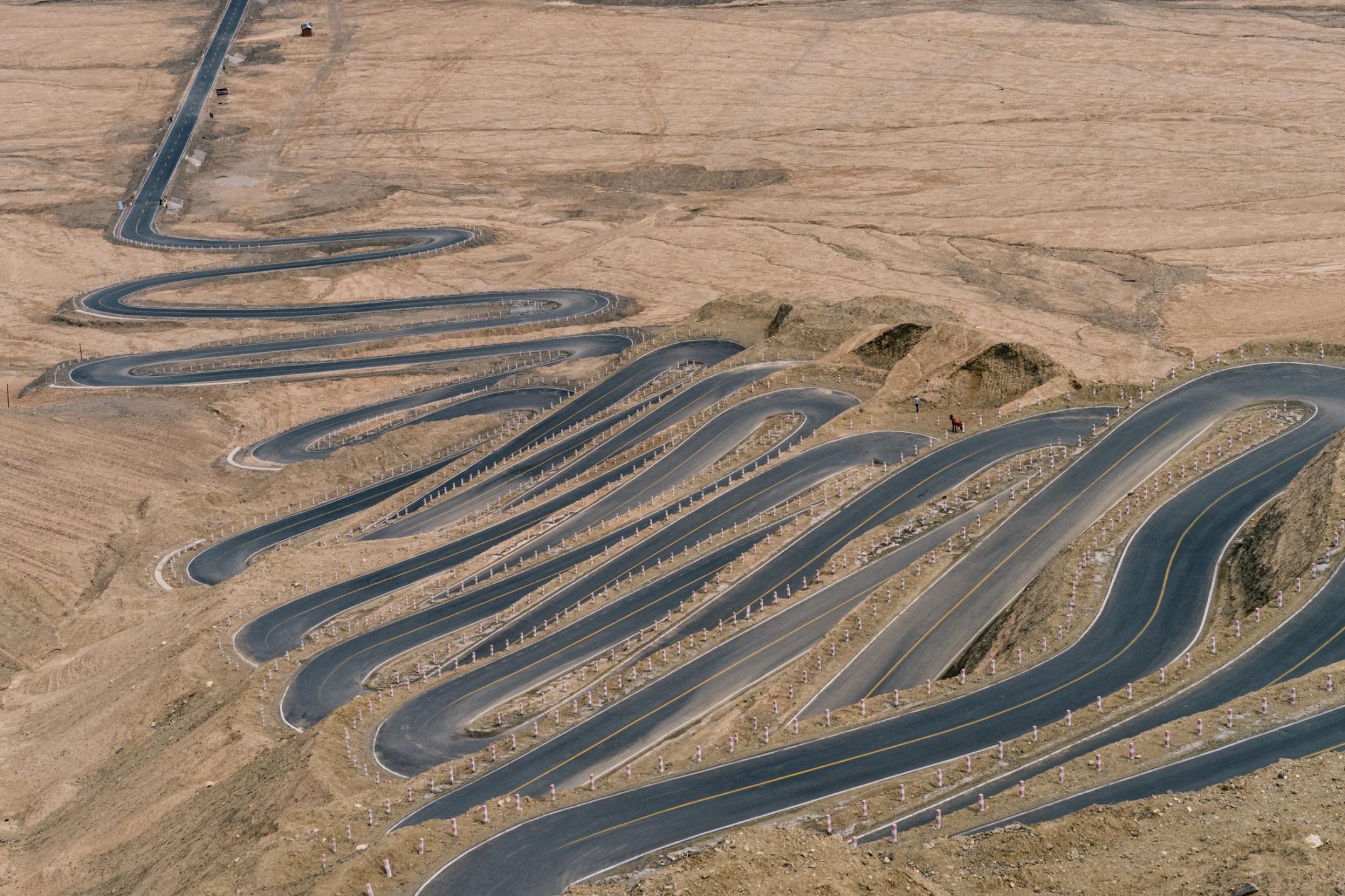
Characteristics: Most Spectacular Highway on the Pamir Plateau | Maximum Elevation: 4,700 meters | Recommended Duration: Approximately 1.5-2 hours
The Panlong Ancient Road connects Kashgar and Tashkurgan County, stretching approximately 130 kilometers as the Pamir Plateau's most spectacular highway. The winding, serpentine road resembles a coiled dragon across the high plateau, hence its name "Panlong" (coiled dragon). Ascending from Kashgar's 1,300-meter elevation to the plateau's 4,700-meter peak, the journey showcases remarkably diverse landscapes.
Engineering Marvel: The road features dozens of hairpin turns, each a masterpiece of engineering design. Along the route, Pamir's grandeur unfolds: snow-capped peaks, ancient glaciers, alpine meadows, and barren deserts appear in succession. At 4,700 meters, it ranks among China's highest highways, with multiple scenic overlooks serving as paradise for photographers.
Travel Tips: The road is treacherous; self-driving is not recommended. The long drive may cause motion sickness; bring appropriate medication. The spectacular scenery warrants frequent photo stops.
🏔️ Muztagh Ata Glacier Park
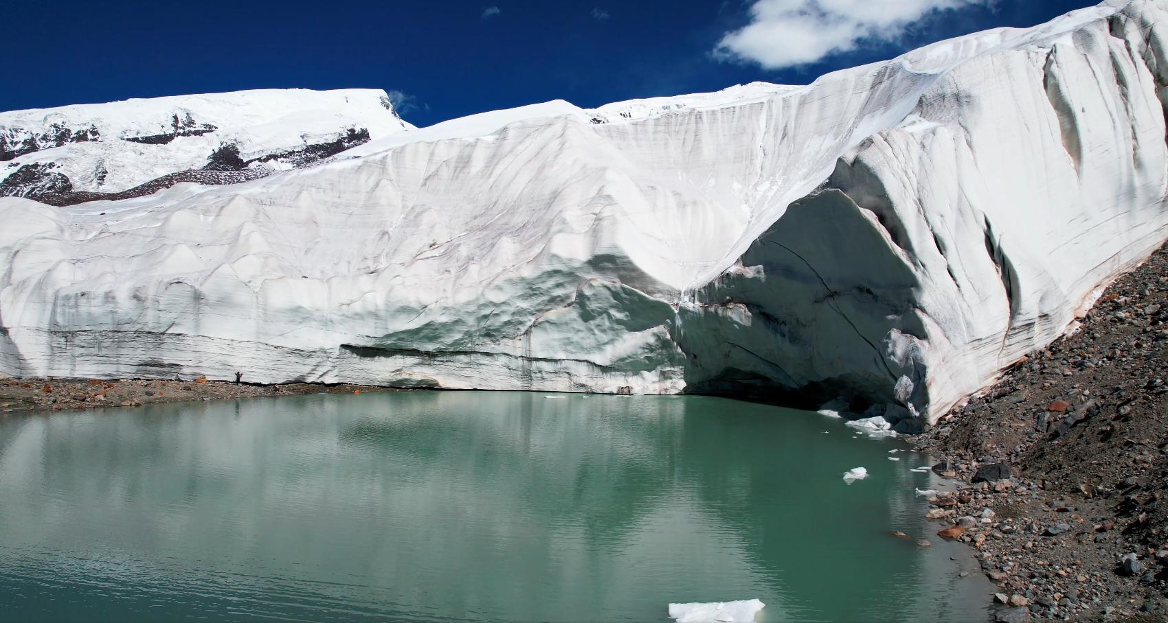
Characteristics: Father of Glaciers | Elevation: 7,509 meters | Recommended Duration: Approximately 3 hours
Muztagh Ata Peak, meaning "Father of Glaciers" in Uyghur, stands at 7,509 meters as the Pamir Plateau's highest mountain. The glacier park at its base offers an ideal location for glacier observation and high-altitude exploration.
Glacier Spectacle: Numerous modern glaciers cover Muztagh Ata's slopes, with the Muztagh Ata Glacier being the most renowned. Covering approximately 200 square kilometers, it ranks as Xinjiang's largest modern glacier. Visitors can take shuttle vehicles for close-up glacier viewing. Glacial meltwater forms pristine alpine lakes that mirror snow peaks in mirror-like clarity, creating poetic landscapes.
Travel Tips: High elevation may cause altitude sickness. Wear heavy down jackets even in summer. Mountain climbing is not recommended; professional guides and safety measures are available at the park.
North Xinjiang · Tianshan Mountain Mysteries
🏔️ Tianshan Heavenly Lake
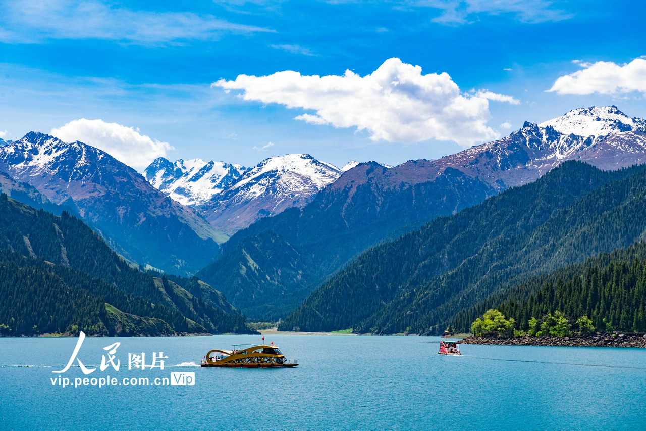
Rating: 5A Scenic Area | UNESCO World Natural Heritage Site | Recommended Duration: Approximately 3-4 hours
Known in antiquity as "Jade Lake," Tianshan Heavenly Lake is a high-altitude glacial moraine lake at the foot of Mount Bogda, sitting at 1,910 meters elevation with a surface area of approximately 4.9 square kilometers. Crystal-clear waters surrounded by snow-capped peaks and ancient spruce forests create a perfect combination of snow, glaciers, forests, and water, earning it the title "Pearl of Tianshan" and recognition as Xinjiang's most internationally renowned natural landmark.
Mythological Significance: The lake holds important status in Chinese mythology. According to ancient texts, Emperor Mu of Zhou traveled westward to meet the Queen Mother of the West at this "Jade Pool," leaving behind the eternal legend "The Queen Mother opens her embroidered window, while bamboo songs echo across the earth." Tang Dynasty poet Li Shangyin's famous verse references this very location. A temple dedicated to the Queen Mother stands beside the lake, where local Kazakh herders conduct traditional ceremonies each year on the third lunar month.
Natural Wonder: This typical high-altitude glacial moraine lake formed approximately 10,000 years ago during the last ice age. Fed by glacial meltwater from Mount Bogda, the lake maintains year-round clarity and brilliant blue color. Dense Tianshan spruce forests surround the lake, harboring rare wildlife including snow leopards, wild yaks, and brown bears. In 2013, Tianshan became China's 45th UNESCO World Heritage Site.
Travel Tips: The scenic area operates shuttle buses; private vehicles are prohibited. Lake cruises offer different perspectives of the lake's beauty.
🏛️ Kizil Thousand Buddha Caves
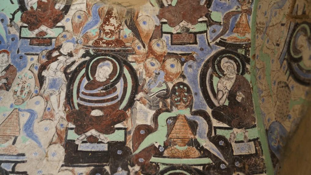
Status: National Key Cultural Relic | Silk Road Buddhist Art Treasury | Recommended Duration: Approximately 1.5 hours
Located approximately 75 kilometers northwest of Kuche County, the Kizil Thousand Buddha Caves represent Xinjiang's largest cave complex with 339 existing grottos. This site preserves abundant Buddhist murals and sculptures, serving as a precious repository for studying ancient Silk Road Buddhist art.
Historical Importance: Excavated beginning in the 3rd century AD, these caves boast over 1,700 years of history, predating Dunhuang's Mogao Caves by 200 years. This former center of Buddhist culture in ancient Kucha produced the renowned monk Kumarajiva, who later translated 384 Buddhist texts in Chang'an, profoundly influencing Chinese Buddhist culture.
Artistic Value: Kizil murals display unique artistic style blending Indian, Persian, and Chinese influences. Mural content includes Buddha images, bodhisattvas, donors, and sutra transformation scenes. The most famous "Thousand Buddha" wall features hundreds of small Buddha images arranged in neat rows, creating a spectacular sight.
Travel Tips: Photography is prohibited in some grottos; please respect regulations. Professional guide services are recommended for deeper understanding of Buddhist art and Silk Road culture.
🌿 Tarim Poplar Forest Park
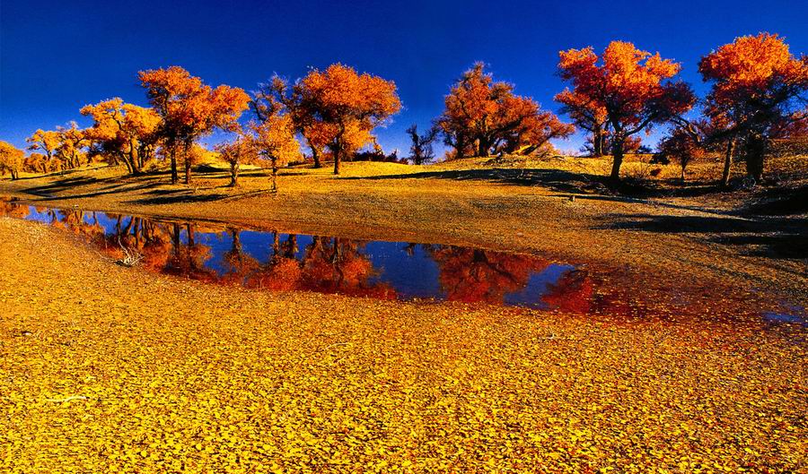
Characteristics: China's Largest Poplar Forest | Best Season: September-October | Recommended Duration: Approximately 2.5 hours
Located south of Korla City, Tarim Poplar Forest Park is China's largest poplar forest reserve, covering approximately 30,000 square kilometers. Each autumn (September-October), poplar leaves turn golden, creating stunning contrasts with the azure Tarim River—a photographer's paradise.
Ecological Value: Poplars, known as "desert heroes," dominate the Tarim River basin vegetation. With lifespans exceeding 300 years, these trees demonstrate remarkable drought and salt-tolerance. Beyond their ecological importance as desert barriers preventing sand expansion, poplar forests provide habitat for rare wildlife including wild camels, wild donkeys, and Tibetan antelopes.
Travel Tips: Autumn offers the best viewing season when poplar leaves turn golden. Early morning provides optimal lighting. Shuttle buses operate throughout the park.
Xinjiang Cultural Characteristics
Silk Road Civilization
Xinjiang served as the core of the ancient Silk Road for over 2,000 years, connecting Eastern and Western civilizations. Han Dynasty diplomat Zhang Qian's mission opened this trade route linking China with the Mediterranean world. Silk, porcelain, spices, and gold exchanged here while Buddhism, Islam, and Christianity spread along these routes, creating a uniquely multicultural landscape.
Islamic Culture
Islam arrived in Xinjiang in the 10th century, becoming the primary faith of Uyghur, Kazakh, and Kyrgyz peoples. With approximately 24,000 mosques throughout Xinjiang, including the renowned Id Kah Mosque in Kashgar, Islamic culture profoundly influences local architecture, music, cuisine, and clothing.
Uyghur Music and Dance
Uyghur culture boasts ancient musical traditions, with the Twelve Muqam being the most important classical form, recognized by UNESCO as intangible cultural heritage in 2005. Uyghur dances feature distinctive rotating and head movements, while traditional instruments like the rawap, dombra, and rubab create enchanting melodies.
Kucha Buddhist Art
Ancient Kucha (modern Kuche) served as a major Buddhist cultural center, with cave temples like Kizil and Kumtula preserving magnificent murals. These sites provide invaluable resources for studying ancient Silk Road Buddhist art and cultural exchange.
Uyghur Handicrafts
Uyghur artisans maintain rich handicraft traditions: Hotan jade carving, Kashgar copperwork, Yengisar knives, and Turpan carpets enjoy national and international renown. Ikat silk, with its vibrant colors and unique patterns, was designated as national-level intangible cultural heritage in 2008.
Nomadic Culture
Kazakh, Kyrgyz, and Mongol peoples have inhabited Xinjiang's grasslands and mountains for generations, developing distinctive nomadic traditions. Felt yurts serve as traditional dwellings, while Kazakh horsemanship and Kyrgyz eagle-hunting represent important aspects of Xinjiang's nomadic heritage.
Tajik High-Altitude Culture
The Tajik people, China's only white ethnic minority, inhabit the Pamir Plateau. While practicing Islam, they maintain ancient Zoroastrian customs. Eagle dance, their most representative traditional dance mimicking soaring eagles, is recognized as national-level intangible cultural heritage.
Xinjiang Cuisine
Xinjiang cuisine centers on lamb and beef, with roasted whole lamb, hand-pulled rice, noodles, flatbread, and baked pastries as signature dishes. Xinjiang fruits—Hami melons, Turpan grapes, Korla pears, and Aksu apples—enjoy national fame. Traditional milk tea, brewed with brick tea and milk, remains an essential daily beverage.
Travel Tips · Essential Information
☀️ Sun Protection Essential
Xinjiang's UV radiation is intense, especially in South Xinjiang and the Pamir Plateau. SPF50+ sunscreen, wide-brimmed hats, and sunglasses are indispensable. Brightly colored clothing provides excellent photography opportunities.
🌡️ Significant Temperature Variations
Xinjiang experiences dramatic temperature swings, with daytime highs reaching 35°C while nighttime lows drop to 10°C or below. The Pamir Plateau shows even more extreme variations. Pack lightweight down jackets or heavy outerwear for flexible layering.
💧 Hydration and Dry Climate
Xinjiang's arid climate requires daily water intake of 2-3 liters. Bring moisturizing spray and lip balm. High-altitude areas require extra hydration to prevent altitude sickness.
📋 Border Pass Requirements
Travel to Tashkurgan County requires a border region travel permit, obtainable from local police stations or online with 3-5 business days processing. Hong Kong, Macau, Taiwan, and foreign nationals should verify entry requirements in advance.
⛰️ Altitude Sickness
The Pamir Plateau's high elevation (3,000-4,000 meters) may cause headaches and shortness of breath. Allow adequate rest upon arrival and avoid strenuous activity. Hotels provide oxygen services if needed.
🕐 Time Zone Considerations
Xinjiang officially uses Beijing Time (UTC+8), but actual sunrise and sunset occur approximately 2 hours later than eastern China. Local residents typically dine at 22:00-23:00 Beijing time, with night markets remaining active late into the evening.
💰 Spending Guide
Xinjiang offers moderate costs. Urumqi taxi starting fare is approximately 10 yuan, with city rides rarely exceeding 30 yuan. Scenic area dining is pricier; bring snacks. Purchase souvenirs from reputable shops to ensure authenticity.
📅 Optimal Travel Seasons
Summer (June-August): Tianshan Heavenly Lake and Pamir Plateau at their most beautiful with pleasant weather.
Autumn (September-October): Golden poplar forests create stunning photography opportunities.
Avoid Winter (December-February): Many attractions close and roads may become snow-blocked.
Special Services
*Sichuan Scenic Spots (Beautiful) — 5 Days | Xinjiang (Even More Beautiful) — 10 Days

Setting out from Kashgar—China's westernmost city—we traverse the Pamir Plateau and journey eastward along the Silk Road, arriving at Urumqi at the foot of the Tian Shan mountains. This single expedition allows you to explore the very essence of both Northern and Southern Xinjiang. Spanning a total distance of over 2,000 kilometers, the itinerary covers more than 15 key scenic attractions, with accommodation provided for 9 nights in 4- to 5-star standard hotels.
Security Assurance
Closing Ceremony
Personal Planning
Meeting Location Map
Loading map...
Passenger Reviews
No reviews yet, be the first traveler to leave a review.!
Sichuan-XinJiang-15Days